Download annotation, mark up with georeferencing

Is there a way to down load mark up lines, rectangles, circles from near map?
With Georeference would be ideal.
Thanks
Best Answer
-
Hi @Suresh_31651,
Unfortunately the MapBrowser does not have the functionality to export your markings as a shapefile or KML layer. The MapBrowser is only able to export imagery content or print screen our imagery with your map markings.
I apologise for the inconvenience this causes you.
Answers
-
Hi @Suresh_31651,
Thanks for reaching out.
If you would like to export the MapBrowser markings, Line, Rectangle and circles with our imagery you will need to use the snapshot tool. This will take a printscreen of your screen, excluding the MapBrowser menus. This will include our imagery and any map markings you have made.
Unfortunately the MapBrowser does not have the ability to export our imagery, georeferenced, with map markings. I would be interested in your use case, so I can provide feedback to the team on your behalf.
- Is this related to your other question about sharing our imagery for public consultation?
- Would you please be able to share some more information about the map markings you are sharing.
- Do you want people to be able to follow a link to view your project content that you built in the MapBrowser?
- Does this content need to be visible over Nearmap imagery or just the roads layer like your other question?
I look forward to your response.
Thanks
Brendan -
- Is this related to your other question about sharing our imagery for public consultation?
sharing Road layer, not imagery.
- Would you please be able to share some more information about the map markings you are sharing.
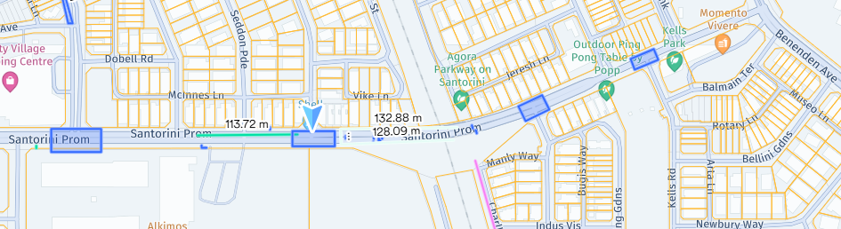
see attached.
- Do you want people to be able to follow a link to view your project content that you built in the MapBrowser? yes
- Does this content need to be visible over Nearmap imagery or just the roads layer like your other question? Just road layer
-
Hi Suresh,
Thanks for the feedback and the example.
Unfortunately there is currently no way that you can share this content from the MapBrowser to external parties. As I mentioned you could export this with the snapshot tool but this feature is a simple printscreen option and wont allow you to georeference the imagery.
Alternatively if you have ArcGIS Online you would be able to build and share the map via their toolset. Our imagery is also able to be integrated via the ArcGIS Online portal integration, or via our APIs.
I like the idea of sharing content, and imagery, eg your project, with people outside of your organization. Ill propose the feedback on your behalf. I can't guarantee when or if we will be able to build this feature but we will investigate your use case.
-
Hi Brendan, thanks for your feedback.
Can I download the shapefile of the mark up only then?
